

Landscape connectivity and network construction of riparian vegetation in typical reach of the middle and lower reaches of Yellow River
-
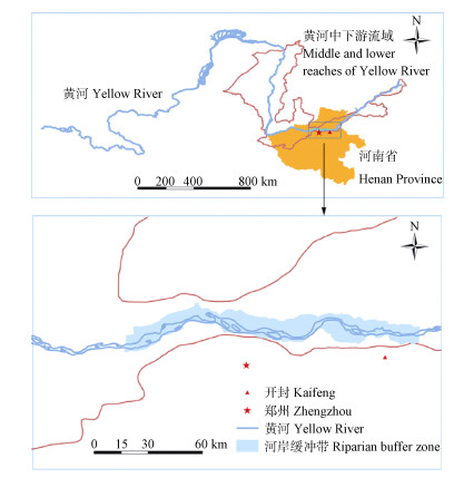
摘要: 植被作为河岸缓冲带生态系统服务形成与维持的基础,在维持生物多样性方面,能为多种物种提供栖息地和迁移廊道。因此,本文以黄河中下游典型河岸缓冲带植被为对象,采用遥感解译、景观连接度指标、斑块重要性评价和廊道网络分析相结合的方法,分析2003年、2009年和2015年研究区的植被景观连接度和斑块重要值变化,并构建河岸缓冲带植被廊道网络,以期为黄河中下游河岸缓冲带生物多样性保护提供支持。结果表明,研究区植被斑块的连接度在2003-2015年呈增加趋势,且随距离阈值的增大而增大;不同距离阈值下,斑块重要值随斑块面积增大而增大,且随距离阈值增大的而增大;小型斑块(0~5 hm2)重要值呈增加趋势,中型斑块(5~10 hm2)重要值呈先增加后降低趋势,而大型斑块( > 10 hm2)重要值呈降低趋势。植被廊道网络分析表明,基于重要生态节点同时考虑沟渠和道路廊道可作为研究区植被廊道网络构建的重要参考。Abstract: Riparian ecosystems form the linkages and exchange zones of matter, energy and information between aquatic and terrestrial ecosystems.The characteristics of such zones significantly influence integrated landscape ecosystem functions from land to riparian regions.Riparian vegetation as an important component of riparian ecosystem, is the basis of the formation and maintenance of riparian buffer zone ecosystem services.However, riparian vegetation has now been widely recognized as fragile and sensitive system requiring conservation as it undergoes strong disturbances and great alteration by anthropogenic activities globally.Conservation activities have largely focused on the restoration or creation of natural areas to facilitate the movement of organisms.This is often based on reliable measurement of landscape connectivity and patch importance.In this study, a typical riparian buffer zone in the middle and lower reaches of Yellow River was analyzed for landscape connectivity and importance of riparian vegetation in 2003, 2009 and 2015 using remote sensing, landscape connectivity indexes, patch importance evaluation and corridor-network analysis.Also the study constructed a riparian vegetation corridor-network in order to provide support for maintaining biodiversity in riparian buffer zones in the middle and lower reaches of Yellow River.The results indicated that landscape connectivity of riparian vegetation increased both from 2003 to 2015 and with increasing threshold distance.Thus the number of links (NL) and the number of the largest component (NLC) of vegetation patches increased from 2003 to 2015 and they increased with increasing threshold distance.However, the number of components decreased from 2003 to 2015 and with increasing threshold distance.The integral index of connectivity (IIC) and the probability of connectivity (PC) increased with increasing threshold distance.Under different threshold distances, the importance value increased with increasing patch area.Thus with increasing threshold distance, the importance value of small patches (0-5 hm2) increased gradually, that of middle patches (5-10 hm2) initially increased and then decreased, while those of large patches ( > 10 hm2) decreased gradually.When the threshold distance was more than 1 000 m, the importance values of small, middle and large patches became stable, indicating that 1 000 m was the optimal threshold distance for the analysis of landscape connectivity in the study area.Ultimately, the corridor-network analysis proved to be important reference for the construction of riparian vegetation corridor-network. It sim-ultaneously considered important ecological nodes, ditches and road corridors in the study area as the established vegetation network system had high corridor node number, network closure and connection degree.In addition, riparian vegetation corridor-network construction should not only prioritize the connection between large patches, but also emphasize the stepping-stone role of small and middle patches between the large patches.
-
![]()
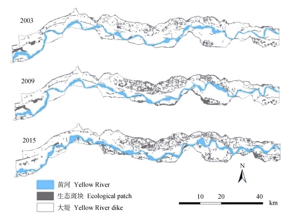
图 2 2003年、2009年和2015年黄河中下游典型河岸缓冲带生态斑块分布
Figure 2. Distribution of ecological patches in the typical riparian buffer zone in the middle and lower reaches of Yellow River in 2003, 2009 and 2015
![]()
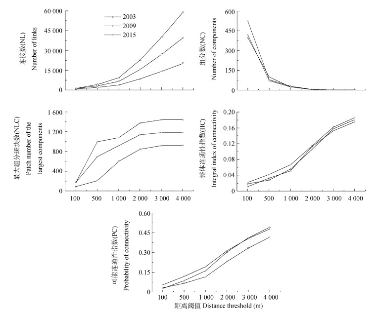
图 3 2003年、2009年和2015年黄河中下游典型河岸缓冲带不同距离阈值下植被景观连接度
Figure 3. Vegetation landscape connectivity under different distance thresholds of the typical riparian buffer zone in the middle and lower reaches of Yellow River in 2003, 2009 and 2015
![]()
图 4 黄河中下游典型河岸缓冲带植被网络节点分布(A)及4种植被网络构建预案(B、C、D、E)
Figure 4. Distribution of vegetation network node (A) and 4 construction plans (B, C, D, E) of vegetation network of the typical riparian buffer zone in the middle and lower reaches of Yellow River
![]()
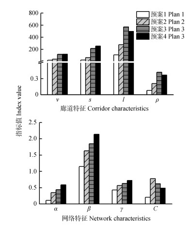
图 5 黄河中下游典型河岸缓冲带不同植被廊道网络预案的廊道和网络结构特征指数
Figure 5. Corridor and network structure characteristics of different vegetation network plans for the typical riparian buffer zone in the middle and lower reaches of Yellow River
![]()
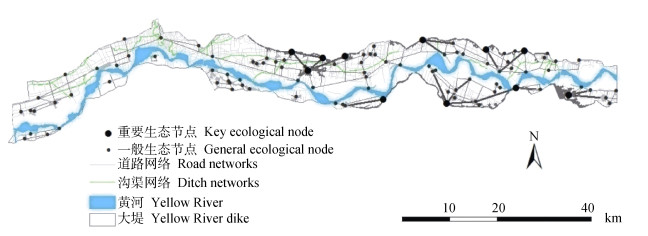
图 6 黄河中下游典型河岸缓冲带植被网络最终构建方案
Figure 6. Final vegetation network plan for the typical riparian buffer zone in the middle and lower reaches of Yellow River
表 1 2003年、2009年和2015年黄河中下游典型河岸缓冲带不同距离阈值下斑块面积与重要值
Table 1 Areas and importance values of vegetation patches with different areas of the typical riparian buffer zone in the middle and lower reaches of Yellow River under different distance thresholds in 2003, 2009 and 2015
斑块面积
Patch area (hm2)年份
Year斑块数
Patch number平均斑块面积
Average patch area (hm2)斑块总面积
Total patch area (hm2)距离阈值
Distance threshold (m)重要值
Importance value标准差
Standard deviation变异系数
Coefficient of variation2003 2009 2015 2003 2009 2015 2003 2009 2015 0~5 2003 573 2.48 1 421.04 100 0.02 0.00 0.01 0.02 0.00 0.02 1.41 1.41 1.41 500 0.06 0.00 0.04 0.08 0.00 0.06 1.41 1.41 1.41 2009 697 2.50 1 742.50 1 000 0.07 0.01 0.05 0.10 0.01 0.06 1.41 1.41 1.41 2 000 0.07 0.01 0.04 0.10 0.01 0.06 1.41 1.41 1.41 2015 857 2.50 2 142.50 3 000 0.07 0.01 0.04 0.09 0.01 0.06 1.41 1.41 1.41 4 000 0.06 0.01 0.04 0.09 0.02 0.05 1.41 1.41 1.41 5~10 2003 137 7.14 978.18 100 0.12 0.01 0.65 0.03 0.01 0.25 0.21 1.36 0.39 500 0.05 0.08 0.51 0.05 0.11 0.54 1.07 1.40 1.06 2009 197 7.50 1 477.50 1 000 0.27 0.21 0.14 0.42 0.53 0.17 1.57 2.54 1.17 2 000 0.28 0.19 0.13 0.44 0.40 0.13 1.56 2.10 1.01 2015 241 7.48 1 473.56 3 000 0.27 0.18 0.12 0.41 0.31 0.11 1.52 1.76 0.87 4 000 0.25 0.16 0.11 0.36 0.25 0.09 1.44 1.55 0.79 > 10 2003 212 293.70 62 264.40 100 9.14 20.26 6.64 12.47 28.26 9.33 1.36 1.40 1.40 500 5.88 13.54 4.16 7.75 18.81 5.66 1.32 1.39 1.36 2009 291 350.14 101 890.74 1 000 1.54 1.30 1.13 2.89 2.99 2.20 1.88 2.31 1.95 2 000 1.62 1.15 1.01 3.07 2.33 1.93 1.90 2.03 1.91 2015 348 249.37 86 780.76 3 000 1.55 1.05 0.91 2.92 1.97 1.70 1.89 1.86 1.86 4 000 1.46 0.99 0.83 2.71 1.74 1.52 1.85 1.77 1.82  下载: 导出CSV
-
[1] 吴昌广, 周志翔, 王鹏程, 等.景观连接度的概念、度量及其应用[J].生态学报, 2010, 30(7):1903-1910 http://www.cnki.com.cn/Article/CJFDTOTAL-STXB201007030.htm Wu C G, Zhou Z X, Wang P C, et al. The concept and measurement of landscape connectivity and its applications[J]. Acta Ecologica Sinica, 2010, 30(7):1903-1910 http://www.cnki.com.cn/Article/CJFDTOTAL-STXB201007030.htm
[2] de la Peña-Domene M, Minor E S. Landscape connectivity and ecological effects[M]//Wang Y Q. Encyclopedia of Natural Resources. New York, NY:CRC Press, 2014:317-323
[3] Baguette M, Van Dyck H. Landscape connectivity and animal behavior:Functional grain as a key determinant for dispersal[J]. Landscape Ecology, 2007, 22(8):1117-1129 doi: 10.1007/s10980-007-9108-4
[4] Gurrutxaga M, Marull J, Domene E, et al. Assessing the integration of landscape connectivity into comprehensive spatial planning in Spain[J]. Landscape Research, 2015, 40(7):817-833 doi: 10.1080/01426397.2015.1031096
[5] 梁国付, 许立民, 丁圣彦.道路对林地景观连接度的影响——以巩义市为例[J].生态学报, 2014, 34(16):4775-4784 http://www.cnki.com.cn/Article/CJFDTOTAL-STXB201416034.htm Liang G F, Xu L M, Ding S Y. Impacts of roads on woodland landscape connectivity:A case study of Gongyi City, Henan Province[J]. Acta Ecologica Sinica, 2014, 34(16):4775-4784 http://www.cnki.com.cn/Article/CJFDTOTAL-STXB201416034.htm
[6] 刘世梁, 杨珏婕, 安晨, 等.基于景观连接度的土地整理生态效应评价[J].生态学杂志, 2012, 31(3):689-695 http://www.cnki.com.cn/Article/CJFDTOTAL-ZJNX201601040.htm Liu S L, Yang J J, An C, et al. Ecological effect of land consolidation:An assessment based on landscape connectivity[J]. Chinese Journal of Ecology, 2012, 31(3):689-695 http://www.cnki.com.cn/Article/CJFDTOTAL-ZJNX201601040.htm
[7] 张宇, 李丽, 吴巩胜, 等.基于生境斑块的滇金丝猴景观连接度分析[J].生态学报, 2016, 36(1):51-58 http://www.cnki.com.cn/Article/CJFDTOTAL-STXB201601006.htm Zhang Y, Li L, Wu G S, et al. Analysis of landscape connectivity of the Yunnan snub-nosed monkeys (Rhinopithecus bieti) based on habitat patches[J]. Acta Ecologica Sinica, 2016, 36(1):51-58 http://www.cnki.com.cn/Article/CJFDTOTAL-STXB201601006.htm
[8] Maguire D Y, James P M A, Buddle C M, et al. Landscape connectivity and insect herbivory:A framework for understanding tradeoffs among ecosystem services[J]. Global Ecology and Conservation, 2015, 4:73-84 doi: 10.1016/j.gecco.2015.05.006
[9] Coulon A, Aben J, Palmer S C F, et al. A stochastic movement simulator improves estimates of landscape connectivity[J]. Ecology, 2015, 96(8):2203-2213 doi: 10.1890/14-1690.1
[10] Liu S L, Deng L, Dong S K, et al. Landscape connectivity dynamics based on network analysis in the Xishuangbanna Nature Reserve, China[J]. Acta Oecologica, 2014, 55:66-77 doi: 10.1016/j.actao.2013.12.001
[11] Zhao H D, Liu S L, Dong S K, et al. Characterizing the importance of habitat patches in maintaining landscape connectivity for Tibetan antelope in the Altun Mountain National Nature Reserve, China[J]. Ecological Research, 2014, 29(6):1065-1075 doi: 10.1007/s11284-014-1193-7
[12] Liu S L, Deng L, Chen L D, et al. Landscape network approach to assess ecological impacts of road projects on biological conservation[J]. Chinese Geographical Science, 2014, 24(1):5-14 doi: 10.1007/s11769-014-0651-z
[13] Ren Y, Deng L Y, Zuo S D, et al. Geographical modeling of spatial interaction between human activity and forest connectivity in an urban landscape of southeast China[J]. Landscape Ecology, 2014, 29(10):1741-1758 doi: 10.1007/s10980-014-0094-z
[14] McIntyre N E, Wright C K, Swain S, et al. Climate forcing of wetland landscape connectivity in the Great Plains[J]. Frontiers in Ecology and the Environment, 2014, 12(1):59-64 doi: 10.1890/120369
[15] Jansson R, Laudon H, Johansson E, et al. The importance of groundwater discharge for plant species number in riparian zones[J]. Ecology, 2007, 88(1):131-139 doi: 10.1890/0012-9658(2007)88[131:TIOGDF]2.0.CO;2
[16] Sabo J L, Sponseller R, Dixon M, et al. Riparian zones increase regional species richness by harboring different, not more, species[J]. Ecology, 2005, 86(1):56-62 doi: 10.1890/04-0668
[17] Tang Q, Bao Y H, He X B, et al. Sedimentation and associated trace metal enrichment in the riparian zone of the Three Gorges Reservoir, China[J]. Science of the Total Environment, 2014, (479/480):258-266
[18] Gageler R, Bonner M, Kirchhof G, et al. Early response of soil properties and function to riparian rainforest restoration[J]. PLoS One, 2014, 9(8):e104198 doi: 10.1371/journal.pone.0104198
[19] Méndez-Toribio M, Zermeño-Hernández I, Ibarra-Manríquez G. Effect of land use on the structure and diversity of riparian vegetation in the Duero river watershed in Michoacán, Mexico[J]. Plant Ecology, 2014, 215(3):285-296 doi: 10.1007/s11258-014-0297-z
[20] Kominoski J S, Shah J J F, Canhoto C, et al. Forecasting functional implications of global changes in riparian plant communities[J]. Frontiers in Ecology and the Environment, 2013, 11(8):423-432 doi: 10.1890/120056
[21] Fremier A K, Kiparsky M, Gmur S, et al. A riparian conservation network for ecological resilience[J]. Biological Conservation, 2015, 191:29-37 doi: 10.1016/j.biocon.2015.06.029
[22] 赵清贺, 卢训令, 汤茜, 等.黄河中下游河岸缓冲带土壤粒径分形特征[J].中国水土保持科学, 2016, 14(5):37-46 http://www.cnki.com.cn/Article/CJFDTOTAL-STBC201605006.htm Zhao Q H, Lu X L, Tang Q, et al. Fractal dimension characteristic of soil particle size in the riparian buffer zone of the middle and lower reaches of the Yellow River[J]. Science of Soil and Water Conservation, 2016, 14(5):37-46 http://www.cnki.com.cn/Article/CJFDTOTAL-STBC201605006.htm
[23] 徐文茜, 汤茜, 丁圣彦.河南新乡黄河湿地鸟类国家级自然保护区景观格局动态分析[J].湿地科学, 2016, 14(2):235-241 http://www.cnki.com.cn/Article/CJFDTOTAL-KXSD201602014.htm Xu W Q, Tang Q, Ding S Y. Landscape pattern dynamic of Xinxiang Yellow River wetland bird national nature reserve, Henan Province[J]. Wetland Science, 2016, 14(2):235-241 http://www.cnki.com.cn/Article/CJFDTOTAL-KXSD201602014.htm
[24] 赵清贺, 马丽娇, 刘倩, 等.黄河中下游典型河岸带植物物种多样性及其对环境的响应[J].生态学杂志, 2015, 34(5):1325-1331 http://www.cnki.com.cn/Article/CJFDTOTAL-STXZ201505022.htm Zhao Q H, Ma L J, Liu Q, et al. Plant species diversity and its response to environmental factors in typical river riparian zone in the middle and lower reaches of Yellow River[J]. Chinese Journal of Ecology, 2015, 34(5):1325-1331 http://www.cnki.com.cn/Article/CJFDTOTAL-STXZ201505022.htm
[25] Cook E A. Landscape structure indices for assessing urban ecological networks[J]. Landscape and Urban Planning, 2002, 58(2/4):269-280 http://www.sciencedirect.com/science/article/pii/S0169204601002262
[26] Ramirez-Reyes C, Bateman B L, Radeloff V C. Effects of habitat suitability and minimum patch size thresholds on the assessment of landscape connectivity for jaguars in the Sierra Gorda, Mexico[J]. Biological Conservation, 2016, 204:296-305 doi: 10.1016/j.biocon.2016.10.020
[27] Kelly V L. Habitat quality and landscape connectivity of riparian corridors for wildlife in southern Illinois[D]. Illinois:Southern Illinois University, 2014
[28] 陈春娣, 吴胜军, Douglas M C, 等.阻力赋值对景观连接模拟的影响[J].生态学报, 2015, 35(22):7367-7376 http://www.cnki.com.cn/Article/CJFDTOTAL-STXB201522011.htm Chen C D, Wu S J, Douglas M C, et al. Effects of changing cost values on landscape connectivity simulation[J]. Acta Ecologica Sinica, 2015, 35(22):7367-7376 http://www.cnki.com.cn/Article/CJFDTOTAL-STXB201522011.htm

计量
- 文章访问数: 1390
- HTML全文浏览量: 140
- PDF下载量: 991
